
|
|
What amazing weather, at the time of writing we are in week four of strong high pressure with back to back dry days, blue skies and very strong sunshine, in fact its been a proper heat wave and the best warm spell we have have experienced in years with temperatures in the low to mid twenties every single day. Needless to say there was little in the way of weather to photograph during this period so like everyone else I enjoyed the sun, caught some rays, had my fair share of BBQs and spent a lot of time filming with my drone thanks to an abundance of calm days. The heat was building and so was the humidity and soon a number of storm scenarios were appearing on the models. England and the south of Ireland had been getting all the action with terrific thunderstorm activity, a tornado, and the SW of Ireland experienced its most prolific night lightning display in years. However as the days passed the unstable air began to advect to the NW and soon N. Ireland was showing big potential.
We had the window period picked out five days in advance and as we got closer to chase day it looked like the charts were not only holding but enhancing the instability, the period from June 1st to June 5th looked to be a busy for storm activity in the N and W and I was already planning on chasing for several days. The main event was Friday June 1st, GFS was showing in excess of 1000 j/kg of CAPE, in fact, some areas were evening showing 1300, with a lifted index of -4, this would be the most significant CAPE set-up of the season so far. However due to high pressure there would be no jet stream aloft so vertical shear would be abscent completely so storms would be of the pulse type. I wasn't expecting too much because of this and I did have concerns for the high humidity which was making the sky very hazy and therefore would reduce storm visibility, I was also concerned about high bases however on the positive side there would be some surface convergence, very strong solar heating, and the high CAPE would form huge updraughts so this was enough to get me excited, there was no question that I would be chasing.
Conor McDonald, Paul Martin, John Fagan and I talked at length about the set-up and our best course of action. Storms could form anywhere, the W and NW of Donegal looked potent as well as the midlands, the latter would be my local chase territory so I would be making my play there. The Met Office had issued a yellow warning for flooding and lightning while Met Eirean issued an amber warning for the south. The night before chase day I filled the van with half a tank of diesel, topped up the air in my tires, checked water and oil levels, then spent half the night examining charts. I was up at 07.00 gathering intel, then packed water, tea and snacks, camera gear all charged and drone packed, I was ready to go when nature gave me a sign. My plan was to begin in the N midlands, my base of operations would be Benbradagh for the great view point then from there I had the option to go N to Limavady, Coleraine, coast, Binevenagh, or along Glenshane Pass or SW to Strabane, all good target areas. If models were correct activity could fire as early as midday. The morning was very warm and humid, the air felt moist against the skin, perfect juice for storms, by 10.00 I observed the sudden formation of high based towers over Maghera, their tops were hard and it looked like storms wanted to form at any moment. I got a call from photographer Nigel McFarland who was going to make a play on these storms too so we decided we would meet at Benbradagh outside Dungiven at 11.30.
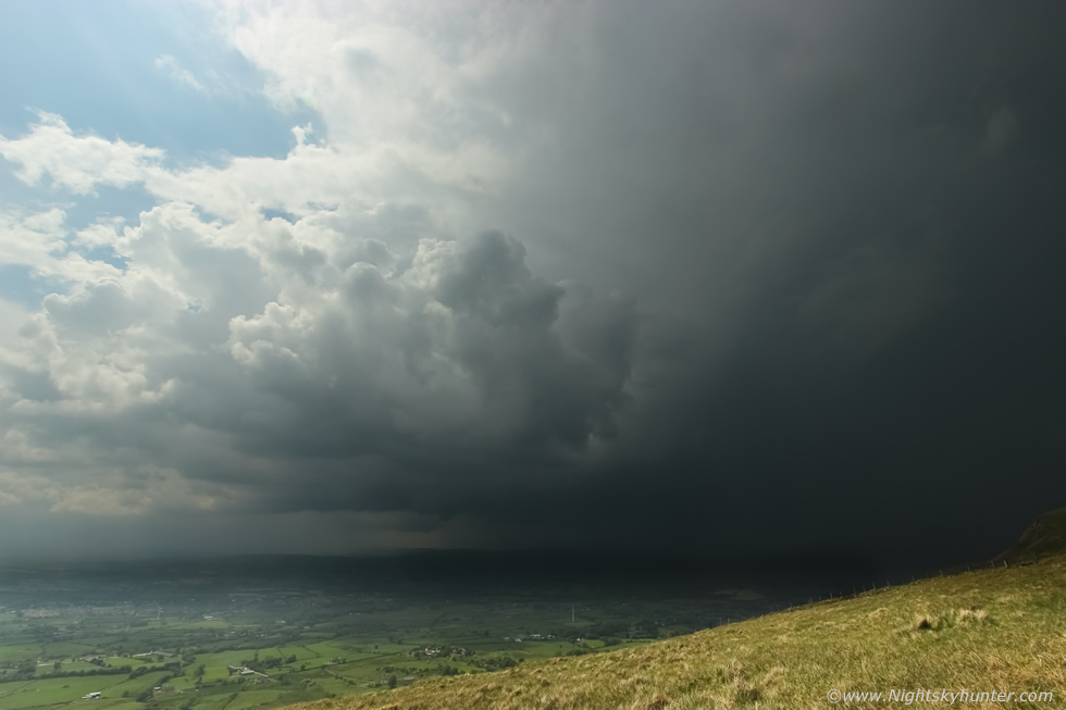
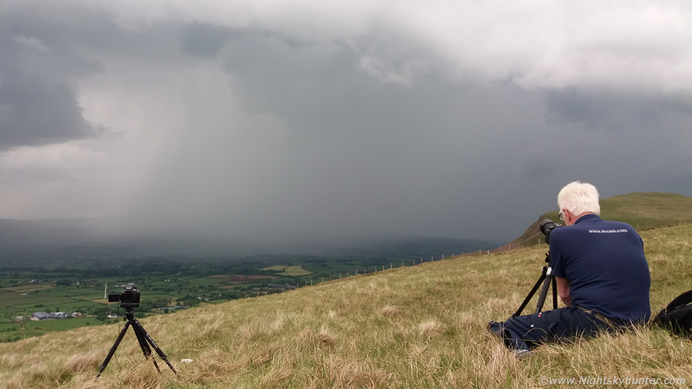
As I drove along Glenshane Pass I observed a huge white tower dominating the sky through my W facing windscreen, I had a feeling there would be a storm at any moment and that tower was in the Benbradagh area, once I arrived on the flank of the mountain I was rite beside the cell, five min's later there was a rumble of thunder, I had a storm already, and it was midday, the models were bang on. I watched the cell over the countryside periodically rumbling away, it didn't have a lot of structure so I wont post images of it however it was great see, success within five minutes, its not often that happens in storm chasing, this was a real treat and anything else would be a bonus from this day. Nigel and I chatted away while pointing out the finer points of the storm and by the time it had moved to the NW we had heard 28 rumbles of thunder. We drove our vans to the top of the mountain and since there was nothing else threatening in the area we decided to hike across the mountain 1km and ascended the summit of Benbradagh. The view was magnificent, horizon all around us, hot and dry, on the horizon to the NW many miles away we could glimpse a storm which was battering Donegal, it's white towers gleamed through the haze. Off in the distance to the SW we spotted a small dark tower with a light strand of precip, it was slowly moving our way and seemed entirely non threatening, we paid it little heed and chatted away then decided to walk back to the vans.
 |
We became engrossed in conversation and didn't look at the sky as we had to watch our footing as we made our way across country over the uneven terrain, then suddenly we looked to our right and there was this big black cell, I was actually shocked, how could that have appeared there so fast?, it looked very big and was developing fast, Nigel said it was the small tower we had seen earlier, I said it looks like its going to rumble any second, no sooner had I said that when a big angry rumble of thunder echoed over the mountain, we both smiled with delight, I held my fist into the air, storm number two and in the same area and track as the first storm, I couldn't believe it. We rushed to the vans, grabbed our gear and a much needed drink of water, then climbed over a wire fence and made our way across the grass and got set-up, the adrenaline was pumping, it rumbled again, it was action time.
 |
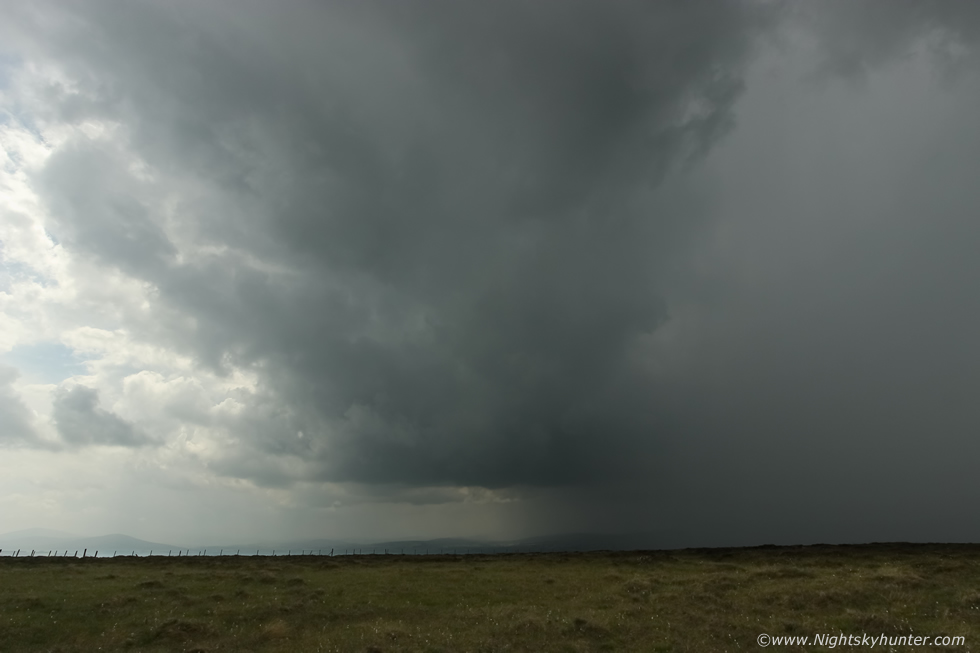
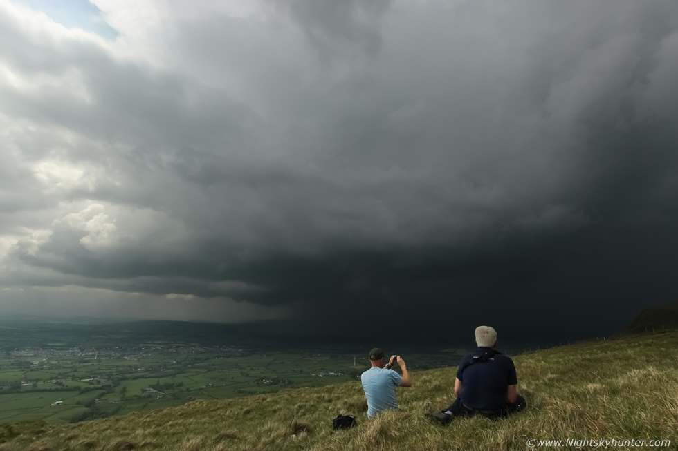
Our viewing point was one of perfection, sitting on the warm grass on top of a mountain with a perfect flat horizon, the storm was in our immediate vicinity with a huge precip core falling to our W with rumbles getting very frequent until the thunder never stopped, Nigel and I were awestruck, we had never expected anything of this caliber, the storm was huge and growing bigger with each minute as it emerged through the heat haze, it looked to be capitalizing on all 1000 j/kg of CAPE, this is facing S with the storm creeping L to R. I grabbed my tripod, mounted the DSLR and 10mm lens, stopped down to F/8 and after some messing about with cable releases in the heat of the moment I began shooting a DSLR time lapse, one image per second. I then filmed segments of the storm with the Go Pro and mobile phone for a vlog.
 |
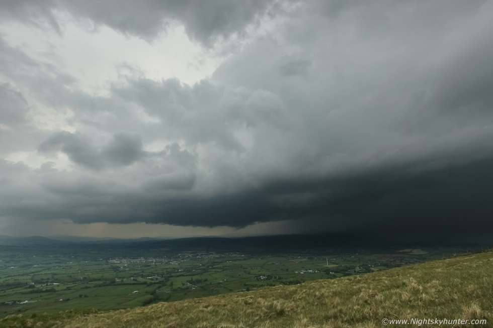
Much to our astonishment the storm seemed to be organizing all the time, getting taller, darker, solid, and mean as hell, this is 10mm portrait of the flanking area as it merged with the lower section of the anvil which streamed overhead. There was no question that there was convergence here, radar showed two cells which merged together to form this huge entity.
 |
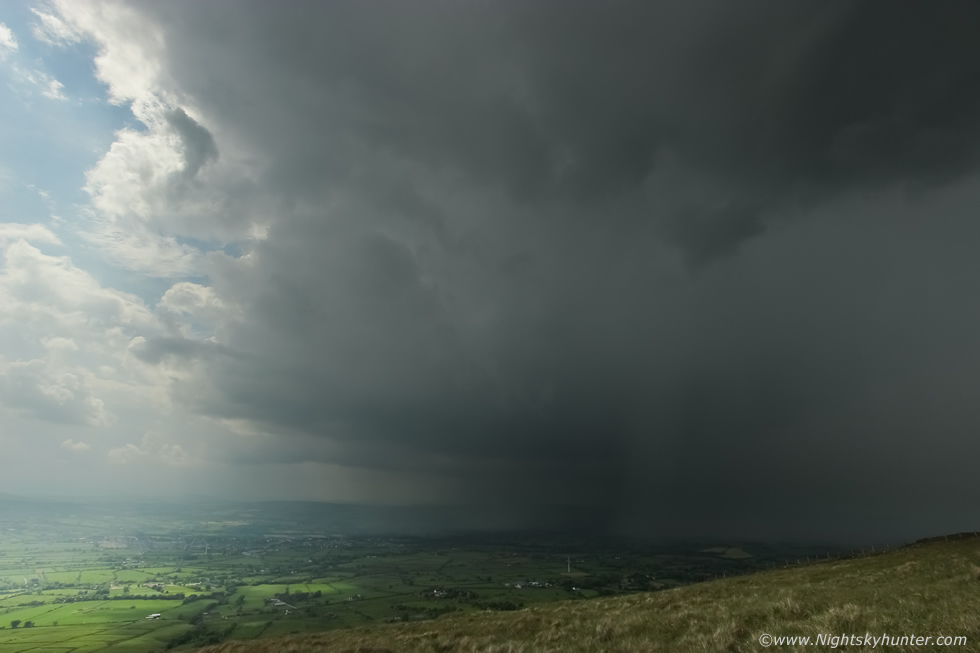
The storm was evolving rapidly and showcasing good structure, the updraught base had dropped in height with lowerings visible through the haze, this was a strong surface based thunderstorm, something which I didn't actually expect to see. This is the flanking area with base on the left, huge updraughts surged aloft with anvil high over our heads with crisp edge beside the bright sun. To the right is the dark precip core, this was dropping curtains of torrential rainfall across the countryside, there were reports on social media from observers under this core who said it was literally like buckets of water being emptied from the sky, roads were saturated and flash flooding was ongoing, storm kept rumbling with thunder and it had no intention of stopping.
 |
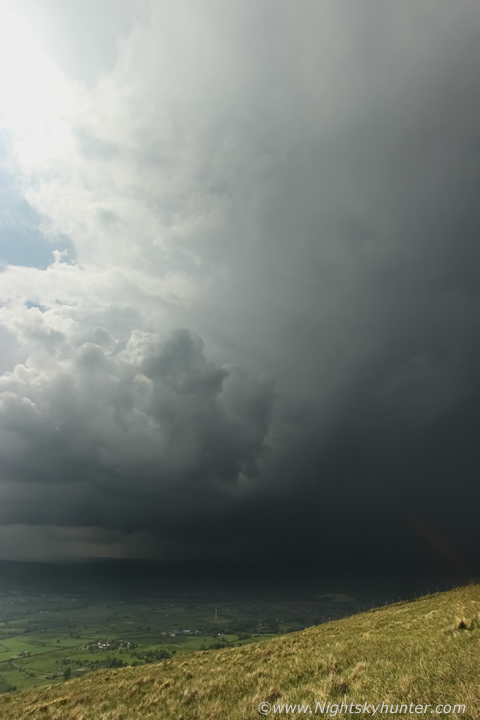
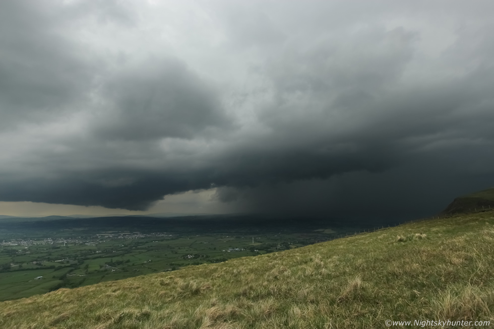
The storm was now a beast!!, we could thunder rumbling away, rumble after rumble, it never stopped, continuous thunder which seemed to go on forever, I couldn't even fit in the structure with the 10mm wide angle, the clouds were solid and varied from near black below to battle ship grey at the mid levels, the sun was shining straight down through it creating harsh high contrast light and a big dynamic range for the camera, you can glimpse a section of the anvil fanning upward to the upper left. The constant thunder was breathtaking, Nigel and I looked at each other and just burst out laughing, it was unreal, we were getting to see nature at her finest and had the perfect seat in the elemental cinema. We could see flashes high up inside the precip core embedded within, however I suspected many of the I-c bolts where also inside the huge updraughts, you can almost tell by the muffled thunder tremors because they sounded like they were rumbling downward from a great height.
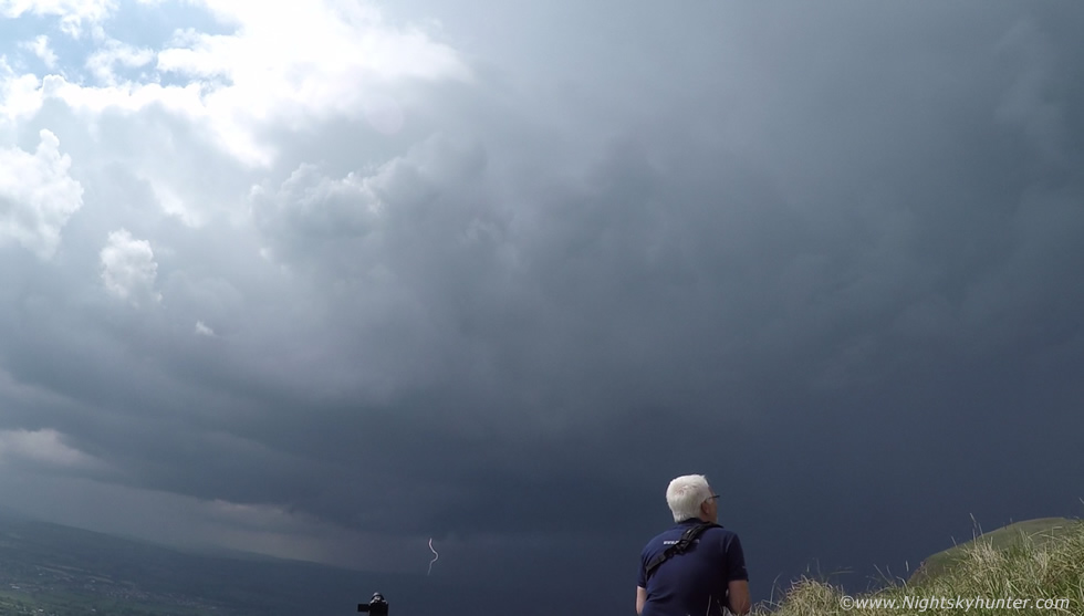 |
I captured a c-g while filming a vlog with the Go Pro, here's a still from the footage, I happened to be moving the camera at the time which is why the view is not level, I really need a hand held gimbal for this kind of shooting.
 |
When I woke up this morning I never thought I had a chance of getting structure like this and a storm of this caliber, this storm would continue producing none stop thunder for over an hour!!!, this goes down as a new personal record for me, never before have I witnessed such a prolific thunder/lightning daytime non-sheared storm as this one, the experience was unbelievable. This storm was the perfect storm I needed for my time lapse photography, the problem with N. Ireland storm's are that they tend to move, sometimes fairly quickly, so shooting a DSLR time lapse is only for short periods of time, then you have to drive after it and when that happens you may not find a good vantage point to begin a new lapse, slow moving storms are a rare luxury in this country, however today nature provided me with the perfect conditions, this was my chance to do what I have always wanted and I took full advantage of the opportunity.
I was shooting non stop time lapse sequences, the lack of wind kept the tripod steady, there was no rain falling on the lens, and the storm was moving so slow it looked like it's movement could be measured in cm's rather than miles, it was not far off stationary however we could perceive a snail-like SW to NE (L to R) motion. The slack surface winds, convergence, slow movement and high water vapor were the perfect ingredients for a significant high precipitation storm, below the core people would have been under monsoon rainfall, in fact, the radar was showing a white core at this time, the updraughts and downdraughts kept going, it was not a nice day under there at all, however by great fortune our view was one of bliss. We watched the structure and every detail in complete comfort, the temp was 22-23 degrees C and the air was humid, we sat at our leisure on the warm grass, the only sound was the thunder and the clicking of my camera shutter, for me this was the dream scenario for shooting a storm time lapse. Check out the lowering, that wasn't a funnel as no rotation was observed, warm inflow rising into the feeding storm in proximity to the cooler moist precip core condensed to form cloud much in the same was as a wall cloud would form.
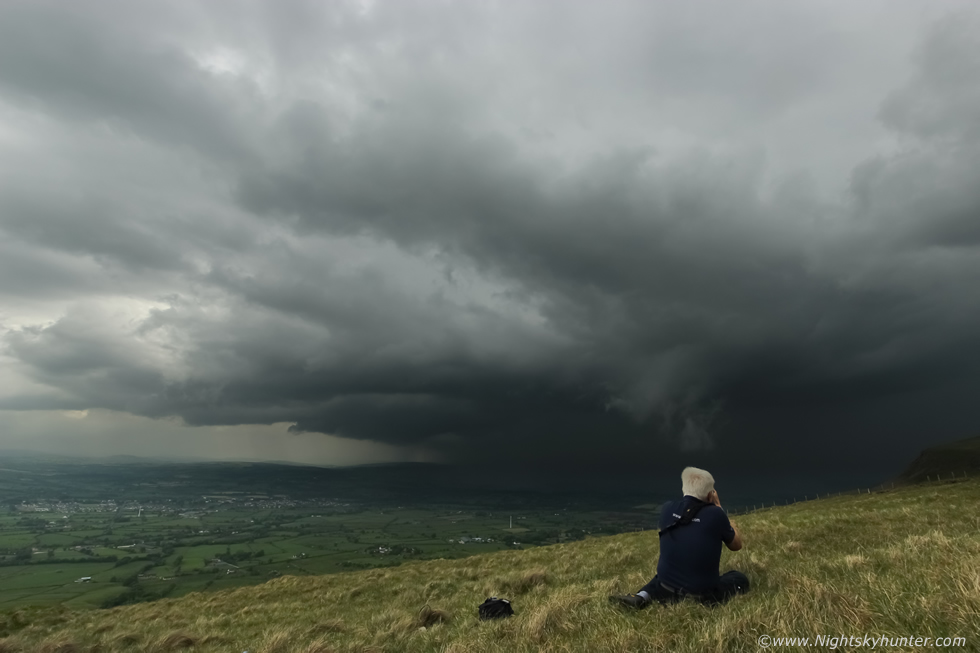 |
Birds chirping, thunder booming, shutter clicking, this was Heaven to me, the sun was cooking our skin, it's not often we get to catch rays and storm watch at the same time, I honestly still couldn't believe our luck with this storm, to think that we had picked this location as a base to start our chase and we would end up getting two storms, one of which was a personal record breaker, and we never had to move once the entire time.
 |
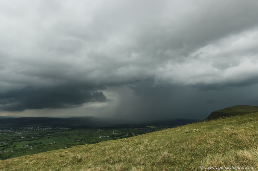
Over an hour later the storm began to show signs of passing it's mature stage and becoming outflow dominant, it also changed direction and began to surge out back towards us. The rain cooled air was now forming a gust front, moving R to L here and towards at same time. The bright section to the upper left is a section of the storm's anvil, thunder still rumbled away.
 |
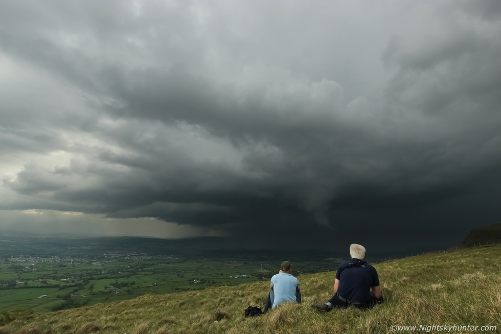
See the flat dark base to the L?, that's a new storm which formed from the outflow from this storm, the outflow acts like a cold front lifting warm buoyant air ahead of it aiding with convective development. That base was the birth of a new storm complex which would cross the Mid-Ulster area causing the severe flooding event in Meadowlane shopping center in Magherafelt.
 |
A rainfoot can be seen at centre, this is when a strong downdraught of air spreads across the surface away from the storm from within the precip core, the wind is stronger at the surface compared to higher up in the core hence why you see this curved shape, it's not a common thing, I might only have seen it three times in my life in this country.
 |
Phone shot showing how close the core was, thunder rumbling and we are still dry with not a drop of rain, Nigel shooting away, my camera on the L still shooting time lapse. I ended up taking over 3000 images making this yet again a new personal record. The storm caught up with us 1.5 hours later and weakened as the new storms in the midlands took centre stage, I will never forget this wonderful storm, its terrific beauty, its long life, solid structure and constant 'talking', without question the best daylight storm I have chased in recent years!
I then hooked up with John Fagan at the Ponderosa, he had just left work at Dungannon and got stuck in slow moving traffic in Cookstown and as a result he missed this storm, he was now hungry for more. Storms had formed on a N-S line over the midlands creeping E so we decided to give chase. We stopped for a look at the Moyola near Tobermore and could see I-c lightning in a distant storm and a new line of bases with towers growing ahead of it, we decided to get closer and made our way S hoping to get ahead of the line long enough to get structure. We punched through a dense core under the lead storm, very bad visibility and road saturated with rainfall, some cars slowed down as they struggled to see, we got through and pulled off the road outside Desertmartin and ran outside to get a shot.
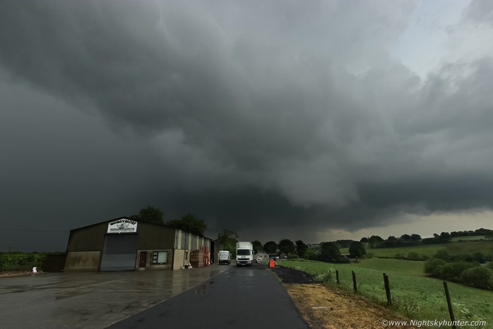 |
Storm passing over 'Moneymore Potatoes' (my aunt and uncle own it) with that torrential core min's away from getting us, this was the same line of storms which flooded Meadowlane, that was only minutes away from happening. The core got us, I only had time for a few snaps before we began getting drenched, but I have to say the rain felt great, it was warm rain like something from the tropics and felt nice and vitalizing after being out in the sun and humid air all day. We then raced on, cut through Moneymore and took the back road to Ballyronan in the hope of getting ahead of it again, however we got stuck behind a slow driver on the country roads which cost us precious time and the line passed on.
At Ballyronan we could hear distant rumbles from storm number four from the Antrim/Belfast area from the other side of the lough and could see the storm's long anvil. We changed our plan and decided to target new cells to the SW over the border and Armagh heading to the SW of the lough later, we relocated to Cookstown and teamed up with Paul Martin, had a brew, checked radar, then we followed John out the back roads to a great spot on the SW side of the lough called Washing Bay. The storms died out later however we stayed here and took in the beautiful view across the lough, Paul and John flew their drones then we watched the sun set on a warm humid evening. It had been a great day, storms, records beaten, and a nice sunset, there was so much moisture that on the way home I had to drive through very dense pockets of fog under a twilight sky, I was home for 11.30 however it would take me until 02.00 to upload all my images and video onto the external hard drive, recharge the batteries, I found out that my mate Conor McDonald had captured a funnel cloud from my home town of Maghera, this made the day even more of a success, but for now I needed some shut eye before more storm chasing the following day.
June 2nd was a similar set-up with over 1000 CAPE yet again, surface convergence looked good so the midlands looked to be a good target area, the NEly breeze would eventually move cells to the SW, so the plan was to get to the midlands near the Sperrins and chase into Omagh then Fermanagh if needs be. I drove off into another warm hazy humid day, when I got on the Omagh road I could see towers firing all over the Sperrins, it looked like we had picked a good area, once on the back roads I saw a giant updraught exploding up, I arrived at Beaghmore Stone Circles where I met up with Paul Martin who was already on the scene, he had just heard thunder, 10 min's later John Fagan arrived then the three of us began watching the skies in earnest. We spent hours watching every cloud movement, the sun was relentless, I was shocked at how intense it was, must have been 24C here, I could feel my arms and neck burning, it was unreal, at times I had to take breaks in the van for shelter, above us huge white updraughts stirred against the hazy blue sky, they were immense, and off the distance solid towers could be seen near Omagh then to the W more could be seen over the Sperrins, it become obvious that a high level cap was holding these storms back, something which hadn't been forecast, it was shocking as convective weather had our location in a moderate risk.
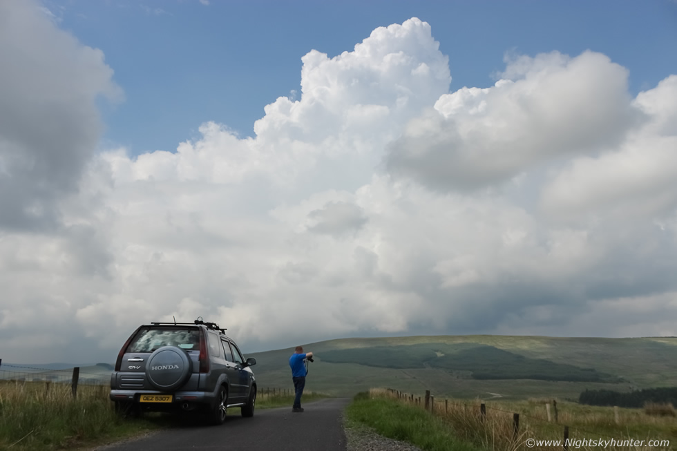 |
Our three vehicles hit the back roads of the mountain and climbed in elevation into the hills, we were very likely the only three chase vehicles on the road at the same time, this was N. Ireland 'chaser convergence', we pulled onto the grass verge and took in the view over this beautiful landscape of hills, valleys, rivers and fields. The birds sang, the bees buzzed and buzzards soared on the thermals. We sat on the warm road and enjoyed a brew while taking in the convection which was going up all around us, this is one of those huge towers, we heard several distant rumbles then Paul and John flew their drones once more to take in the scenery.
 |
By 17.00 the cap didn't break in this area so I decided to time lapse this strong updraught which boiled directly overhead, this was with the 50mm lens, I shot numerous stills for a time lapse of this scene. We went back to Beaghmore, watched the skies for funnels, then drove through a heavy core on the Omagh road with rainbows and called it a day, John headed for Dungannon and I for Cookstown, later Roisin and I got a storm rite beside TESCOS, it had no structure but it was great hearing the rumbles, a sound I never get tired of hearing. Even though we didn't get any close range storms this day on the hills we still had a fabulous time watching those beautiful updraughts in the hot sunshine, hours of nature and fresh air, the chase over the Sperrins was the stuff of memories to come.
Full storm vlog covering the chases on June 1st and 2nd, featuring three storms and convection, filmed with mobile phone camera, Go Pro and DSLR time lapse. This is really more of a memory for me so I can look back on this storm however I hope it gives you can idea of what it was like to be there with a sense of presence as if you where there with me.
DSLR time lapse of the Benbradagh beast shot with Canon 600D and Samyang 10mm prime lens, 3000 images to get 1 min 40 sec's of time lapse footage, the most I have ever taken for a project like this. Using a modern day lap top it took me 8 hours to edit and render the finished lapse, however I had to re-do two segments so it actually took 10 hours, best watched at 1080p with large window.
Time lapse of one of the boiling updraughts over the Sperrins at 50mm, 183 stills rendered for this, if only you could feel the heat and humidity when this was taken. I chased again on the third day, the skew-Ts were showing better soundings to the NE however storms fired in the SW so I was out of play however we did get some beautiful high based towers pass close to my home before sunset which was a beautiful way to end the day. What a great period of weather, four weeks of warm sun and three days of storm chasing, I love this time of year, thanks for reading.
Martin McKenna